Clark Fork
Hope
New Port
Priest River
Bonners Ferry
Fort Steele
Coeur d' Alene
  Gallery
  City Map
  City Data
  Sightseeing
Spokane
  Gallery
  City Map
  City Data
  Sightseeing

1st Avenue
2nd Avenue
3rd Avenue
4th Avenue
5th Avenue
Cedar Street
Bridge Street
Main Street
US 95 Highway
US 2 Highway
Long Bridge
Coldwater Creek
Sand Creek
Schweitzer Creek
Edge Water Resort
Bonner County Museum
Pend D' Oreille Winery
Shopping Mall
Railroad Gallery
Old Gallery
Caribou Creek Ranch
Karen's Gallery
Kaji's Gallery

Sandpoint City Map
Sandpoint City Data
Sandpoint City Review
Sightseeng Information
Hotel Information
Transportation
Old Brouchure


Sandpoint City Beach
Pend Oreille Cruise
Sandpoint Marina
Pack River
Sunny Side
Summer Gallery
Frycreek
Trestle Creek
Pend Oreille River
Albeni Falls Dam
Priest Lake
Water Paradise
Schweitzer Resort
Lake Pend Oreille Map

State of Idaho
Travelogue, 2002
Travelogue, 2006
Homestay, 1977
What's New ?
Sandpoint Link
Top Page


New York, NY
Washington,D.C.
Braintree, MA
Columbus, GA
St. George Island, FL
Charleston, SC
San Francisco, CA
Los Angeles, CA
Pasadena, CA
Disneyland, CA
Tropical Islands

Punta Cana, Dominica

Oahu Is., Hawaii

Cebu Is., Philippines

Asian Cities

Beijing, China

Shanghai, China

Nanjing, China

Taipei, Taiwan

Manila, Philippines

Munich, Germany
Dubai, UAE


Cities | Homestay | Home

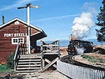
Fort Steele, British Columbia, Canada

Located about 10 miles north-east of Cranbrook on Highway 93/95, Fort Steele is easily reached by the Southern Trans-Provincial Highway, No.3, which follows the historic Dewdney Trail much of its length. Gold brought the first rush of settlers to the Kootenays in the 1860's. John Galbraith capitalized by setting up a ferry service at the present site of Fort Steele, then known as Galbraith's Ferry. By the 1880's the introdction of cattle ranching led to diputes with the native people about land ownership. In 1887 Superintendet Sam Steele and 75 men built the first North West Mounted Police post in B.C., restored peaceful relations without firing a shot, and in a year's time returned to the prairies. The grateful settlers changed the name of the site of the post from Galbraith's Ferry to Fort Steele. In the 1890's Fort Steele was the site of a speculative boom, and a town quickly grew up as rumour spread it was to be "capital of Kootenay". However the routing of the railway around Fort Steele in favour of Cranbrook in 1898 turned Fort Steele into a ghost town in a few years. Fort Steele was created a historic park in 1961. Development has aimed at rebuilding a typical Kootenay town of the 1890 - 1905 period.

You can enlarge each photo by clicking on the photo, new window will open.

The Blockhouse


Perry Creek Water Wheel

Fisher Peak
Museum Building

General Store Fortsteele Water Works


Copyright (C) Mapquest.com
Galbraith's Ferry Office


Kershaw Store

Windsor Hotel

The Drug Store Prospector Printing Office


Copyright (C) Mapquest.com
The "Shay"

St. Anthony's Catholic Church The Schoolhouse
The "Dunnrobin"

St. John the Devine Anglican Church Hanson House
Wild Horse Theatre

Fort Steel Entrance Brouchure of the Theatre
Ticket of Theatre

Ticket for Train Ride
Park View

Park View


Park View

Park View

Park View


Steam Locomotive

Steam Locomotive

Train Ride


Wild Horse Theatre

Train Ride

Wild Horse Theatre


Park View

City Bakery
    Fort Steele Map

Top Page Lake Pend Oreille Sandpoint Coeur d' Alene Spokane
Clark Fork Hope, East Hope Bonners Ferry Newport Priest River
Fort Steele Sandpoint Rail Road Caribou Creek Ranch States of Idaho What's new?
Copyright (C) 2002-2008 Satoshi Shimizu. All Rights Reserved.
inserted by FC2 system