Sandpoint Gallery
City Information
Travelogue etc
|
New York, NY
Washington,D.C.
Braintree, MA
Columbus, GA
St. George Island, FL
Charleston, SC
San Francisco, CA
Los Angeles, CA
Pasadena, CA
Disneyland, CA
Tropical Islands
Punta Cana, Dominica
Oahu Is., Hawaii
Cebu Is., Philippines
Asian Cities
Beijing, China
Shanghai, China
Nanjing, China
Taipei, Taiwan
Manila, Philippines
Munich, Germany
Dubai, UAE
|
|
|
|
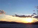
Lake Pend Oreille
When someone tries to introduce Sandpoint, he cannot avoid to tell about Lake Pend Oreille (pronounced Pon-duh-ray). The name of the lake is originated from French hunters from Canada. The pronounciation of Pend Oreille is like Ponderay, the small town located near by Sandpoint. The French term meanings like "looks like ear" turned into Pend Oreille. The surrounding length of the lake is around 143 mies and the are is about 180 square miles, which is the biggest lake in Idaho state and one of the big lake in the United Sates of America. The depth of the lake is guessed about 1,170 feets or more, the very deep lake and its clearness, water quality is pretty good. From the west, Pend Oreille River flows from the national edge inbetween U.S. and Canada, from the northern east, Pack River flows. Sandpoint is located on the northern west of the lake and upper area there have a great skiing area called, Schweitzer basin ski resort. Also you can enjoy boat fishing, camping, water skiing and everything enjoyable around Lake Pend Oreille where is the one of the
greatest beautiful area.
|

Copyright (C) Sandpoint Online.com
|
Sandpoint
The biggest town around Lake Pend Oreille, national highway 2 and 95, 2 intercontinental railroad, the important point of the transportation.
City Beach
The biggest sand beach in the Pend Oreille area.
Hope
Hope is the small town 45 minutes drive from Sandpoint toward east, Eagan Mt is behind the town.
Clark Fork
Delta zone where Clark Fork River flows from Montana state.
Pack River
Pack River Flatz is not famous but has curious and wonderful view especially in the summer.
Sunny Side
The resort place eastern Sandpoint, in between Oden and Kootenai bay. A lot of villas are standing there.
Pend Oreille River
Originated around the upper Washington satate and flows toward west to Washington and Canada.
Fry Creek
The opposite to Sandpoint where a boart deck and some vilas are standing.
|
|
Lake Pend Oreille Gallery
|
Lake Pend Oreille Area Camp Ground
Lake Pend Oreille (pronounced Pon-duh-ray) is the largest natural body of fresh watr in Idaho and one of the largest in the Western United States. Over 43 miles length, over 111 miles of shoreline, 1,100 feet deep in places, home to a variety of fish including world-record size Kamloops. Remnant of a huge lake that once extended from the Canadian border down through the Purcell Trench (the route of Highway 95) to the area of Spokane. Receding glaciers dammed the trench near Bayview and formed what we now call Lake Pend Oreille. The lake's name is derived from an Indian Tribe called Pend Oreilles by early French trappers because they wore pendant ornaments in their ear lobes. Fish from the bridge and break Lake Pend Oreille's world record 37 pound kamloop record.
RILEY CREEK CAMPGROUND:
15 miles west of Sandpoint, 1 mile south of Laclede. Attraction: Pend Oreille River. Water, toilets, showers, 32' trailer space, dump station, dumpster, boat launch, dock, phone, handicapped access.
GARFIELD BAY CAMPGROUND:
14 miles south east of Sandpoint on Garfield Bay Road. Attraction: Lake Pend Oreille. Water, Toilets, 22' trailer space, boat launch.
GREEN BAY CAMPGROUND:
16 miles south east of Sandpoint. Attraction: Lake Pend Oreille. Toilet.
SAM OWEN CAMPGROUND:
17 miles east of Sandpoint. Attraction: Lake Pend Oreille and David Thompson Game Refuge. Water, Toilets, 22' trailer space, dump station, covered picnic area, boat ramp, dock, HOST.
SPRINGY POINT CAMPGROUND:
4.5 miles south west of Sandpoint on Lakeshore Drive. Attraction: Pend Oreille River. Water, toilets, showers, 32' trailer space, dump station, dumpster, boat ramp, dock, phone, swimming.
WHISKEY ROCK CAMPGROUND:
30 miles south west of Clark Fork, 10 miles south of Garfield Bay. Attraction: Lake Pend Oreille. Toilet, dock.
FARRAGUT STATE PARK:
25 miles south of Sandpoint, 4 miles east of Athol. Attraction:Lake Pend Oreille. Water, toilets, showers, 32' trailer space, dump station, dumpster, boat launch, dock, swimming. 4,000-acre park offering miles of hiking and horse trails, a 60,000-person natural amphitheater, group camping facilities, pleasant beach, model airplane flying field, competition rifle range.
ROUND LAKE STATE PARK:
10 miles south of Sandpoint, 2 miles west on Dufort Road. Attraction: Round Lake. Water, toilets, showers, 24' trailer space, dump station, boat launch, dock, swimming, HOST.
|
 Lake Pend Oreille Map
|
|