|
|
 Please click here for JAPANESE version Please click here for JAPANESE version
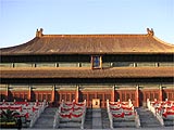
Beijing is located in the northeastern corner of China. Its city limits extend some 80km (50mi), including the urban and the suburban areas and the nine counties under its administration - in other words, it's huge. Though it may not appear so in the shambles of arrival, Beijing is a place of very orderly design. Long, straight boulevards and avenues are crisscrossed by a network of lanes. Places of interest are either very easy to find if they're on the avenues, or impossible to find if they're buried down the hutongs (narrow alleys).
The Forbidden City acts like a bull's-eye, surrounded by a network of roads, including five ring roads which cup the city centre in concentric circles. The First Ring Rd is a mapmaker's fiction and just part of the grid around the Forbidden City. However, the Second, Third, Fourth and Fifth (opened in 2002) are multi-lane freeways. Roughly within the Second Ring Rd are the four central districts: Xicheng, Dongcheng, Chongwen and Xuanwu. Outside the Second Ring Rd are the so-called 'suburban' (now urbanised) districts of Chaoyang (east), Fengtai (southwest) and Haidian (northwest). Then there are the 'villages' (li). Beijing was once surrounded by many tiny villages, though over time these have in fact become neighbourhoods within the megalopolis.
|
|
Beijing Photo Gallery and City Map
|
 Sandpoint, Idaho
Photo Gallery and Information of Sandpoint, Idaho
|
 Charleston, South Carolina
Photo Gallery and Information of Charleston, South Carolina
|
 Columbus, Georgia
Photo Gallery and Information of Columbus
|
 St. George Island, Florida
Photo Gallery of St. George Island, Florida
|
 New York City, NY
Gallery and Information of New York City
|
 San Francisco, California
Photo Gallery and Information of San Francisco
|
 Munich, Germany
Photo Gallery of the capital of Bayern, Germany
|
 Tropical Islands
Beautiful Gallery of Punta Cana, Dominica and Hawaii
|
|