![[Logo]](icons/sfo_logo.jpg "[Go to Top]")
San Francisco Information
|
Sandpoint, ID
New York, NY
Washington, D.C.
Braintree, MA
San Francisco, CA
Columbus, GA
St. George Island, FL
Charleston, SC
Los Angeles, CA
Pasadena, CA
Disneyland, CA
Tropical Island
Punta Cana, Dominica
Oahu Is., Hawaii
Cebu Is., Philippines
Asian Cities
Beijing, China
Shanghai, China
Nanjing, China
Taipei, Taiwan
Manila, Philippines
Munich, Germany
Dubai, U.A.E.
|
|
|
|
San Francisco Sightseeing Information
|
Sightseeing Area in San Francisco
![[City Map of San Francisco]](images/maps/sfo2x.jpg)
|
|
Union Square
Union Square is located in central downtown area and a lot of boutiques and brand shops are standing around the square. The name "Union" originated from the Civil War, the "Northern Union", a lot of people got together here for the demonstration against Southern alliance. The piller in the square is the memorial of the victory of America-Spain War at Manila, Philippine. The underground of the square is the huge parking space.
Shops around the Square: Tiffany & Co., Armani, Brooks Brothers, Gucci, Disney Store, Levi's Store, SAKS Fifth Avenue, Macy's, Ghurja, Luis Vuitton, Bvlgari, Burberry, Cartier, Hermes, Max Mara, Polo Ralph Lauren etc.
Access
Powell-Mason/Hyde Line
Muni Metro F,J,K,L,M,N,S Line, BART Powell Station
Muni Bus 2,3,4,30,45,38
Map
Union Square Detail Map
|

|
Page Top
SoMa (South of Market)
The area, just sourthern of Market Street has been re-developed and called "SoMa", has a large convention center, museum or academic facilities. San Francisco station for Caltrain is also located here to connect with Muni Metro N. The base ball park for San Francisco Giants, SBC park is also in this place. ->MAP
Access
Muni Metro N Line (connecting with Caltrain Station)
Muni Bus 14
|

|
Yarba Buena Gardens
701 Mission St.
Tue.-Sun. 11:00-17:00
Adults $6.00
Open in 1993 by the cooperation of world famous architects or artists. It is the complex consists of art center, Espramade garden, Metreon, convention center and works for the citizen as an oasys.
San Francisco Museum of Modern Arts (SFMOMA)
151 3rd St.
Thu.-Tue. 11:00-18:00
Adults $10.00
MOMA is well know in New York City but here it is the 2nd largest modern art museum. The building was designed by Mario Boatta with 5 streets. The museum has more than 15 thousands of collections and exhibits with rotation by the season.
Moscone Convention Center
747 Howard St.
The biggest convention center of San Francisco is standing southern neighbor to Yarba Buena Gardens. It has arch shaped ceiling with very specific style of architecture where the events have been held almost throughout the year.
Page Top
Bay Bridge
Bay Bridge is the suspension bridge between Oakland and San Francisco which has 13.5 km length with 2 streets of automobile exclusive traffic. Its importance is much larger than that of Golden Gate Bridge because it is used as Freeway #80 and located between two big cities of northern California. Only the way toward west requires $3.00 as a fare. The bridge is divided into 2 section at Yarba Buena Island. The view from the cost of north-east San Francisco is quite beautiful.
|

|
Page Top
Financial District
At the east end of Market Street, the skyscrapers are standing and so called "Wall Street in West Coast", which has a lot of banks or financial company office, sorrounded by many sightseeing spot but has different atmosphere with business men and women. The icon of the area should be "Trans America Pyramid" and "Embarcadero Center". ->MAP
|

|
Trans America Pyramid
600 Montgomery St.
Trans America Pyramid, the highest building in San Francisco, is one of the icon of the city, especially of Financial District. Its triangle shape is very unique and can be seen from everywhere in the city. It is the head quarter of the company providing financial service. Be noted that the building is not open for the public.
Access
Powell-Mason line, get off at Washinton St. and walk east for 4 blocks
Ferry Building
1 Ferry Building
Mon-Fri 10:00-18:00, Sat 9:00-18:00 Sun 11:00-17:00
The Ferry Building is know with its clock tower. It was renewed in 2003 as the big foods market for the citizen. You can find a lot of San Francisco unique foods, mostly fruites and vegitables here.
Access
Muni Metro F,J,K,L,M,N and BART Embarcadero Sta.
Embarcadero Center
Sacramento St. (bet. Justin Herman Plaza & Sansome St.)
Embarcadero Center is the huge complex with 6 blocks wide, which is standing the opposite of Ferry Building at Embarcadero where the Market Street ends at the eastern edge of the city. There are a lot of sculpture which were contributed by world wide artists.
Access
Muni Metro F,J,K,L,M,N and BART Embarcadero Sta.
Rincon Center
191 Spear St.
Rincon Center is located behind Federal Reserve Bank and is famous for its public hall which has artificial rain. A lot of restaurants, cafes are at this center.
Access
Muni Metro F,J,K,L,M,N and BART Embarcadero Sta.
Page Top
China Town
The Chinatown in San Francisco, which is one of the biggest Chinese community in the United States, began at the Portsmouth Square where the first immigrants got together to have a small community in Goldrush era. Their rabourhood gave the threat to the white and it caused boycott movement and law prohibitting Chinese to come in except the merchants. The law was renewed in 1942 and the Chinese community had grown bigger. You can enjoy the totally different atmosphere here than the other area and also enjoy shopping.
->MAP
|

|
Access
2 blocks north from Union Square. Walk Bush St. toward east.
Walk Columbus Ave. toward Grant Ave.
California Line Grant Ave. or Stockton St.
Muni Bus 15,30 California St.
Chinese Historical Society America Chinese Historical Society America
965 Clay St. (at Stockton St.)
Established in 1963 for the purpose of saving the historical and cultural inheritance and the history itself. On the basement floor, it has the museum where you can learn the Chinese immigrant.
Page Top
Nob Hill
This are began its history when Dr. Arthur Hayne built his home on the top of the hill in 1865. At that time, a steep slope let people hesitating to live in such place but the development of the Cable Car System changed the area into the place where the wealth people live in. The name, "Nob Hill" is known to be originated from the word "Nabob" which means "Rich". It is also known as that the Big 4 of the railroad lived. ->MAP
Luxurious Hotels : Fairmont San Francisco, Mark Hopkins Inter-Continental, Renaissance Stanford Court Hotel, Ritz-Carlton San Francisco
|
|
Access
California Line Grant Ave./Stockton St.
Muni Bus 1
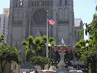
Grace Cathedral
1100 California St.
It is one of the icon of Nob Hill which was built in 1849 as a Gothic styled cathedral, imitation of the Cathedrale Nortre-Dame in Paris. It was burn out by the earthquake disaster in 1906 and rebuilt in 1964. The park in front of the cathedral is Huntington Park where a lot of people are always relax.
Access
Powell-Mason line California St. and Powell St.
Cable Car Museum
1201 Mason St. at Washington St.
Apr.-Sep.10:00-18:00 everyday
Oct.-Mar.10:00-17:00 everyday
Fare : free
When you get off the Cable Car at the crossing of Jackson and Mason Street, you can find a blick built museum which is the Cable Car Museum and the power for the cabel is created inside this building. The museum has the exhibition floor at 1st fl, where you can enjoy the vintage car, photos, old facilities and the model cable cars.
Access
Powell-Mason, Powell-Hyde Jackson St/Mson St. Washington St/Mason St
Page Top
Pacific Haights
Pacific Haights is western neighbor to Nob Hill and is well known as having a lot of traditional Victorian Houses. You can enjoy the walking tour for 2 and half hours to watch those beautiful houses and enjoy the life style through the interior. If you want to enjoy shopping, Fillmore St. is my recommendation. ->MAP
Haas-Lilienthal House
2007 Franklin St. (bet. Wahington & Jackson St.)
|

|
Victorian Home Walking
335 Powell St. (Wenstin St. Francis Hotel lobby)
The point to watch Victorian Houses
Southern of Alta Plaza
Southern of Lafayette Park
Along Green St. and Union St. (bet. Scott St and Laguna St)
Access
Muni Bus 41,45 for Union Street, 1 for Lafayette Park, 12 for Franklin St.
Alamo Square
The view from this square is often on the post cards or on the photographies because the wide view toward the downtown and 7 Victorian Houses are so beautiful. It is located on the middle of the hill and a lot of citizens are enjoying walking with their dogs.
Access
Muni Bus 5 (Steiner St. and walk 1 block toward south)�@21(Steiner St.)
Chestnut Street
Chestnut Street is just 1 block northern of Lombard Street where are a lot of variety of shops, restaurants and iscecream shops. This shopping area is totally not for the tourists but for the citizens, so that you can see and touch the life of San Francisco.
Access
Muni Bus 30
Page Top
Japan Town
Japan Town is the oasis for the Japanese citizen and tourists where are a lot of Japanese restaurants and shops. The center of the town is Japan Center which has the icon, "Five Street Pagoda". But personally, it doesn't look like Japanese style... If you compare with China Town, the size is much smaller and it reflects the culture of Japanese people. ->MAP
Access
California Line Van Ness Ave. then transit to Muni Bus 1
Muni Bus 1,2,3,4
|

|
Page Top
Civic Center
Civic Center is the area where Market St. and Van Ness Ave. meet together which has govermental or public cultural facilities such as City Hall, civic auditorium, state goverment, library and Federal Government building. ->MAP
City Hall
1. Dr. Carlton B. Goodlett Pl.
|

|
The beautiful dome of the building is the feature of the City Hall of San Francisco which was designed by Arthur Brown Jr. who also designed Coit Tower and Opera House in this City.
Access
Muni Metro, BART Civic Center Station
Muni Bus 5,6,21,47,49
War Memorial Opera House
301 Van Ness Ave.
The Opera House is standing just oposit of the City Hall which was desined by Arthur Brown Jr. with French Baloque Style.
Asian Art Museum
200 Larkin St.
Fare $10.00 (Adults)
Tue.-Sun. Open 10:00-17:00
This museum was removed from Golden Gate Park in March, 2003 which has the collection of the arts of Asia, including Japan and eastern Asia and also Western Asia.
Page Top
Fisherman's Wharf
Fisherman's Wharf is located on the north-west edge of the city and it had been used as the wharf for Italian Fishermans, then grew famous as the one of the world famous sightseeing spot in this city. It includes Pier 39 as the eastern edge and Ghirardeli Square as west. A lot of the shops, restaurants are on Jefferson Street. Also the cruises toward Arcatlaz and around San Francisco Bay are departing here. ->MAP
|

|
Access
Muni Metro F line is stopping inside Fisherman's Wharf.
Powell-Hyde line stops in front of Ghirardeli Square.
Powell-Mason kine stops at Bay Street, 4 streets away from Jefferson St.
Muni Bus 10,15,19,30,39,47,49,82
Pier 39
Beach St. & Embarcadero
The most famous pier in San Francisco should be Pier 39, but it is no longer the pier but the shopping mall. In the narrow and long pier area, hundreds of shops provide their service including gifts, foods, bevarage and so on. You can enjoy sea lions on from the K dock. You should be noted to take care of your safety because a lot of people are here.
Aquarium of the Bay
At Pier 39, the Acquarium can show a lot of sort of fishes living around the Bay through the crystal tunnel. The Aquarium is divided into 4 categories, Discover the Bay, Under the Bay, Touch the Bay, Save the Bay and you can leard by categories.
Ghirardeli Square
900 North Point St., Suite 100
Ghirardeli is one of the famous gift (chocolate) in San Francisco. The square is renewed from the chocolate factory into the shopping center. The large signboard is easy to be seen. There are seven buildings with the name of chocolate in the square, located on the western zone of Fisherman's Wharf.
Cannery
2801 Leavenworth St. (bet. Beach and Jefferson Sts.)
Cannery is also the shopping mall renovated from the factory of canned foods. Its blick structure was reused and a lot of foods shops are in this building. Sometimes you can enjoy the performance at the courtyard.
Fort Mason
Fort Mason is on the western edge of Fisherman's Wharf and it had been a institute for the forces. There is a museum to exhibit the facilities there and the park area inside is used for the relaxation time for the citizen.
Access
Powell-Hyde line
Muni Bus 10,28,30,49
National Moritime Museum
This is the ship-shaped museum just close to the Ghirardeli Square which is exhibiting the ocean, the Bay and ship related goods.
Access
Powell-Hyde Line
Muni Bus 10,28,30,49
Page Top
Alcatraz Island
Alcatraz Island is 3km away from Fisherman's Wharf which has totally precipice which disallow prisoners to breakout. It was found in 18th century by Spanish and named "Isla se los alcatraces" and used as the "jail island" for a long while. It had been used as penitentiary from 1934 to 1963 and it was famous with Alfonso Capone. The tour ferry is departing at Pier 41.
Access
Only the ferry is avairable from Pier 41.
|

|
Page Top
North Beach
North beach is called as "Little Italy" because of its location, just neighbor to Fisherman's Wharf, the Italian Fisher's base. The center of the area is Columbus Avenue, which is one of the street goes aslant to the checkboard. The night spot is around Washington Square. ->MAP
Access
Muni Bus 15,30,45
|
|
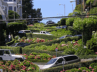
Lombard Street
The street, called "the Crookedest Street" was created because of the checkboard system which required the same lenght for all area ignoring its height, so that this steep slope was made. Just start from the top, Hyde Street down to Leavenworth Street with 8 curves. The flowerbed along this winding road will be full-blown with flowers in Spring and early summer. You can see the beautiful site toward the Telegraph Hill and Coit Tower from the staicase for pedestrian.
Access
Powell-Hyde line Lombard St.
Washington Square
The park in the middle of North Beach, which is facing the twin church, St. Peter & Paul Church, which was built for Italian and took almost 40 years. The park is mostly for the immigrants and it stands for this area's characteristics.
Page Top
Telegraph Hill
Telegraph Hill is located just neighbor to North Beach, where the Coit Tower is standing on. The eastern edge is precipice. It is very steep slope so that the checkboard system could not applied here. Other than Coit Tower, it is the silent residential area. ->MAP
Coit Tower
1 Telegraph Hill Blvd.
Adults $3.75
|

|
On the top of Telegraph Hill, you can see the tower which is looks like the nozzle of the fire engine. It is Coit Tower which was built by the inheritance of Lilie Hitchcock Coit who loved this City. You can enjoy the 360 degree beautiful view from the top of the tower.
Access
Muni Bus 39
Page Top
Presidio
Presidio includes the north-west area of San Francisco City, covering Golden Gate Bridge as the northern edge to Golden Gate Park as sourthern. The area has great nature so that the people can enjoy walking, cycling and other activities here. ->MAP
Golden Gate Bridge
|

|
It is of course the world most famous bridge and is the icon of San Francisco, which has 2789 meters long and 66 meters height from the sea level, which was because navy required to allow the warship go under the bridge. The suspension pole is 227 meters high and its height is as tall as skyscrapers. The view of the bridge is best from Fort Point National Historic Site. Also, as a long distance view, from Twin Peaks is the other best angle to see this bridge. The color, "International Orange" was for easy-seen even in a dark fog for the ships. The name "golden" was not from "Gold Rush" but from Turkish Golden Horn which was imagined from the view of San Francisco Bay. The transit bus is avairable to access here from Market Street and also Muni Bus (10, 20, 50, 60, 70, 80, 90) are the way to visit here.
Fort Point National Historic Site
It was originally a fort against the aggression to defend San Francisco which had more than 100 cannons. It is located just under Golden Gate Bridge and rennovated to the museum which exhibits the military facilities.
Cliff House & Seal Rocks
Seal Rocks is on the very edge of northern and western San Francisco where seals are getting on except the mid summer. The location is at the precipice where Cliff House is standing. Cliff house is the resthouse to enjoy watching Seal Rocks which was rebuilt in 1909 after the several fire disasters.
Access
Muni Bus 38, 38L at the terminal, then walk along Point Lobos Ave. for about 5 minutes.
Clement Street
Other than Chinatown, it is the one of the area where the Chinese people are living. Not only Chinese, a lot of immigrants created here a various culture here and you can enjoy the reality of those culture because the area is not target for the tourist.
Access
Muni Bus 2
Golden Gate Park
It is the one of the world biggest developed park which has 5 km (east-west) width and 800 meters height (north-south). Inside the park, Japanese Tea Garden, Strybing Arboretum and Botanical Garden, Conservatory of Flowers and a lot of facilities for sports. It also offers the walking tour. The Japan tea garden is much fit to Japanese ancient culture than Japan Town. In the Botanical Garden, you can see more than 7,500 kinds of rare plants and gees or swans at the pond. The Conservatory of Flowers was built as the Victorian style, therefore you can also enjoy its beautiful outlook as well as flowers. For the sports, you can enjoy golf, tennis, cycling, roller skating, jogging, picnic and boat.
Access
Muni Bus 21
Page Top
Haight Ashbury
Haight Ashbury is well know as a cradle of the culture of hippy which was the reflection against war and turbulence of the age in 1960's. Recently still there are a lot of club of Rock and Roll or Pank Rock which converge the younger people. The area is sourthen San Francisco and almost the checkboard system is innabale to apply that makes it difficult to grab the location simply by the street name. ->MAP
Access
Muni Bus 6,7,71
Page Top
Mission
Mission is east-south neighbor to Haight Ashbury which has a lot of Hispanic Community. Mission Dolores Church is the icon of the area and also it includes Castro and Twin Peaks.
|
|
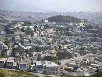
Twin Peaks
The two hills which has 276 and 278 meters height are the one of the greatest place to enjoy watching the town. It is rather tough to walk to the top, it's recommended to take taxi to visit. If you are lucky to visit with fine weather, you can see all of the city, including Golden Gate Bridge and Bay Bridge. ->MAP
Access
Muni Metro F line Castro Sta. then transit to Muni Bus 37 or Taxi
Castro Street
Castro is the end terminal of Muni Metro line F, which is famous with the communities of gay. The rainbow color is the symbol of that culture. You can enjoy "Cruisin' the Castro", walking tour with $45.
Access
Muni Metro F Line
Page Top
|
|