|
|
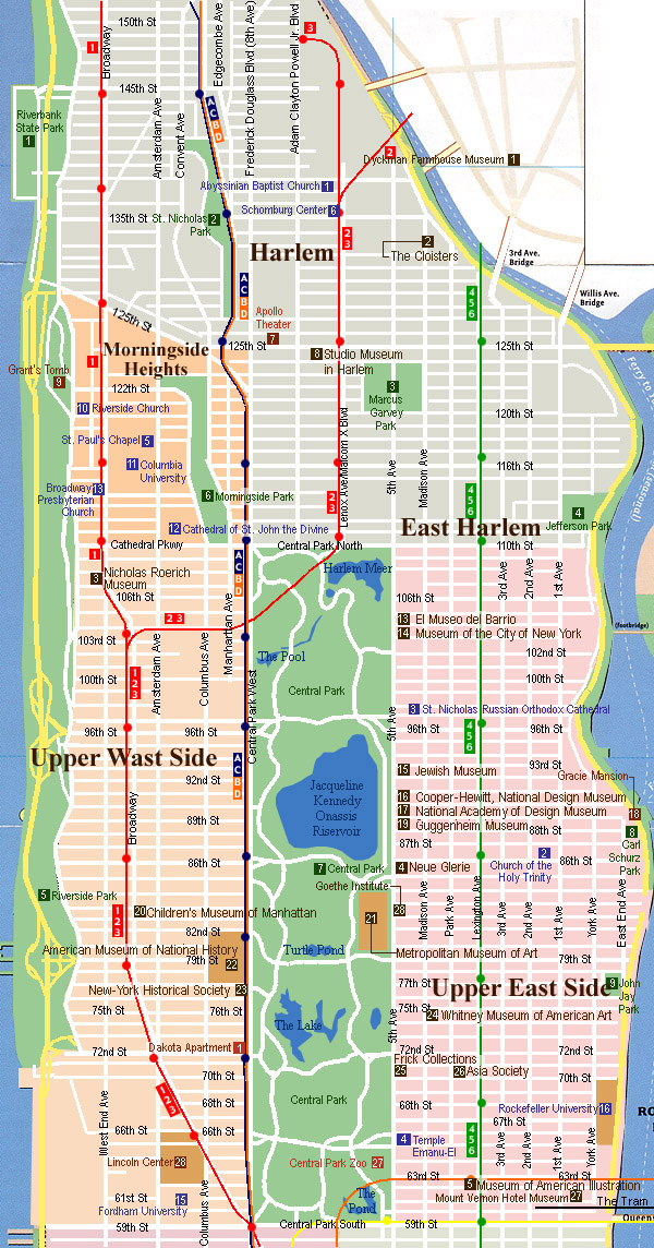
Uptown Map, New York
Uptown, Manhattan New York City
Uptown expand from the Central Park south to Harlem, including Upper East Side, Upper West Side, Harlem and Morningside Heights. On the other hand, Washington Heights and Inwood are widely defined in Uptown but I will treat those area as a separate area from Uptown.
|
Detailed Map
Central Park click to open detailed map
Central Park spans two and a half miles from 59th Street to 110th Street and half a mile from Fifth Avenue to Eighth Avenue and was the first urban landscaped park in the United States. Originally conceived in the salons of wealthy New Yorkers in the early 1850's, the park project spanned more than a decade and cost the city ten million dollars. Today, the park is home to numerous restaurants, playgrounds, the Metropolitan Museum, the Central Park Zoo, and Wollman Rink.
Upper East Side Up click to open detailed map
The Upper East Side stretches from 59th Street to 96th Street, including Lennox Hill and Yorkville. Its western boundary is Central Park; its eastern boundary is the East River. Major sights include Central Park, Museum Mile (Guggenheim Museum, Metropolitan Museum, Whitney Museum and more), Gracie Mansion and six historic districts.
Madison Avenue click to open detailed map
Madison Avenue is the other shopping street rather for the rich people living in the City which also has most of the luxurious brand shops where you can enjoy the feeling that you are like a celebrity !
Upper West Side click to open detailed map
Home to such venerable New York landmarks as Lincoln Center, Columbia University and St. John the Divine Cathedral, the Upper West Side stretches from 59th Street to 123rd Street, including Morningside Heights. Its eastern boundary is Central Park; its western boundary is the Hudson River.
Harlem click to open detailed map
Harlem is an area in northern Manhattan which includes Hamilton Heights and El Barrio (Spanish Harlem). In 1658, Governor Peter Stuyvesant established Harlem, naming it Nieuw Harlem after the Dutch city of Harlem. From 1920 until about 1930, Harlem was the center of an African American cultural movement known as the Harlem Renaissance. The East Harlem/El Barrio community is bounded by First Avenue to Fifth Avenue and from East 96th Street to East 125th Street; the population is primarily Puerto Rican and African-American.
Hamilton Heights is a residential historic district north of Morningside Heights and south of Washington Heights which includes Sugar Hill. Sugar Hill extends from Edgecomb Avenue to Amsterdam Avenue, and from 145 Street to 155 Street. The name "Sugar Hill" originated in the late 1920's when rich African-Americans began moving into the "sweet and expensive" area.
Morningside Heights click to open detailed map
Morningside Heights is the academic quarter of New York City. It stretches irregularly from about 106th Street to about 123rd Street between Morningside Park and Riverside Park on the Upper West Side of Manhattan. From the top of a 135-foot bluff, it overlooks the Hudson River on one side and Harlem on the other. It is about 20 minutes from midtown Manhattan by subway and the area has the second-lowest crime rate in Manhattan. With apartments on the "Gold Coast" of Riverside Drive routinely selling for over $1,000,000, the Heights is one of the more desirable residential neighborhoods in Manhattan.
Washington Heights / Inwood click to open detailed map
Washington Heights and Inwood (WaHI) and Marble Hill are the three northernmost neighborhoods in Manhattan in New York City. Although they are part of "The City", this section of Manhattan is generally ignored by most tourist maps, whose northern edge is usually depicted as 96th Street or 125th Street.
Click on the area to see detail map
 Uptown Photo Gallery
|
|